When we left Ohio on October 4th our plan was to drive to northern North Carolina. Unfortunately we did not make it that far because we had a flat tire on I 77 in West Virginia. We heard a loud POP and pulled over right away. The inside rear tire on the passenger side had blown. Dan contacted Good Sam emergency road service and three hours later we were back on the road travelling south. I was glad to move on because when the tractor trailers zoomed by it shook the RV and made me feel a little scared. We made it to Wytheville, VA that night and travelled on to Myrtle Beach the next day. In addition to daughter Donna and kids, we got together with son Doug and friends who were attending the Bike Rally that weekend. On a picture perfect Saturday we were able to attend a band competition where Jessica (color guard) and Chris (baritone) performed for their high school and Daimen played the trumpet for his band. We were so very impressed with the quality of the bands and all the hard work that went into the performances.
We had two days of chill and gloom brought on by a cold front. but the weather cleared up and sunshine returned. Along with enjoying quality time with the grand kids we took walks on the beach, rode bikes, and did some sightseeing. Myrtle Beach has a way of changing from year to year.
Our weekend at the Navy campground north of Charleston, SC was full of fun and sun and more quality time with another set of grand kids. On Monday morning we took off for our last leg of our journey. Fortunately it was an uneventful trip, and we arrived home safe and sound.
We were gone about 5 1/2 months and logged 7672 miles on the motor home. In addition we drove another 7112 miles in the car when we toured the different areas of Wyoming, Montana, Idaho, and Oregon. We have memories of people and places to last our lifetime.
Wednesday, October 17, 2012
Tuesday, September 25, 2012
Our journey home - Oregon to Ohio
After enjoying the lush green land and beautiful water scenes of western Oregon we headed east through the dry mountains of eastern Oregon and Idaho. The landscape was brown except in areas that were irrigated.

We passed many cattle and horse ranches and lots of wide open spaces. When we traveled through Wyoming we passed through the Rocky Mountains and crossed the continental divide at 7000ft. We climbed to the highest point on I 80 at 8640 and dropped back down. Dan's famous saying became, "Here we go again" up the hills and down the hills. The RV did quite well. We didn't speed up the mountains, but we made it! We passed the huge statue of Lincoln that we remembered from the trip west.

The campground where we stopped in eastern Wyoming was a ranch with lots of animals including bison, horses, cattle, llamas, and camels. We were quite astonished and took a double take when we drove past them.

We never did find out why they were there, but during the summer they had lots of activities for families so that must have been part of it.
The rest of the trip through Nebraska, Iowa, Illinois, Indiana, and Ohio was uneventful. The breadbasket of America was very dry, but there were lots and lots of cornfields and hay fields. One object that we saw over and over again was the windmill. I never did get a really good picture but this one gives you the idea.

As we drove along we passed many large trucks transporting the windmill turbines. When we stopped at a rest area we got a close up look at them. They are really BIG!

From Oregon to Ohio we logged 2435 miles in seven days. We took our time and traveled between 300 and 400 miles a day depending on campground availability. The weather cooperated, and the only rain we experienced was at night. So now we are spending time with son Dan, Kelly, Mitch, Lacey, and Matt in Ohio and plan to visit friends in PA. We'll leave next week for South Carolina to see Donna and Doug and families.
Friday, September 21, 2012
Oregon - Columbia River Gorge
We drove from the Oregon coast north to I 84 and west along the Columbia River to Memaloose State Park. We chose this campground because it was in the center of the area that we wanted to investigate. The drive along the Columbia River was gorgeous. We began our exploration at the Columbia Gorge Discovery Center and Museum. It gave us a good overview of the history, geology, and transportation of the area including the Native Americans, Lewis & Clark, and the Oregon Trail. A nearby city, The Dalles, was our next stop where we looked around the city and enjoyed a picnic by the river. It was the first end of the Oregon Trail. We drove to The Dalles Dam but the visitor center was not open. The dam was an impressive sight.

Instead of taking I 84 east we drove along the Historic Columbia River Highway, the original route 30 constructed in 1922 that connected Portland to The Dalles. We thought the view from the interstate was amazing, but the scenes from this two lane road were spectacular. Here's a picture looking up to one viewpoint. It's hard to see but there are people at the very top looking down. That's where we were headed.

Once we got to the top we had a panoramic view of the area. Once again the pictures can't capture how truly beautiful it was.

This is the S curve in the road that we took to the top.

Here are a few more shots of what we saw.


After our drive along the scenic highway we headed west to Hood River, the windsurfing capital of North America. We didn't see any windsurfing going on while we were there. We drove south to an area called the Fruit Loop. It consists of orchards, fruit stands, vineyards, lavender fields, and nut and berry farms. We discovered that 1/3 of the nation's pears are produced there. We chose to stop at the Gorge White House because it is a century old working farm and listed on the National Registry of Historic Places. In the main house a variety of wines were available for tasting and purchase. In a building beside the house produce and flowers were sold. As we looked in the back yard we could see areas where customers can pick their own flowers and fruit.

The pears that we bought were scrumptious. We were amazed at all the orchards in the area.
On the way back we saw a spot on the map called Panoramic Point and decided to investigate. We wove our way up to the top of the hill to see what we could see. We were a bit underwhelmed. Mostly what we saw were fruit orchards.

As we looked to the south we could vaguely see Mt. Hood, the 11,235 mountain in the distance. Look carefully in the center of the picture and you may see it too.

The following day we planned to cross the river and travel west along the river in Washington to Camas to tour the Pendleton Woolen Mills factory. After that we were going to cross back over to Oregon and drive along more of the Historic Columbia River Highway. There were several waterfalls and another dam that we wanted to see. Instead of that fun day of exploration we spent the day in the RV because I got hit with a stomach virus. We tried to extend our stay another day, but all the sites were taken. So we accepted the fact that we couldn't see everything anyway and appreciated all the wonderful sights of Oregon that we did get to see. After a summer of adventures it was time to head back east.
Friday, September 14, 2012
Oregon - the coast
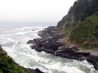
Our campsite at Beachside State Park had an oceanfront view. The problem was it was so cloudy and foggy that we barely saw the ocean. The beach was very hard to walk on, but the sound of the waves coming in was soothing to hear. We were able to see the tallest and shortest lighthouses and several others up and down the coast. We walked to the top of the tallest one and had a foggy view of the ocean. The Pacific coast is so much different from what we are used to on the Atlantic. There are lots of large and small rocks and sharp hillsides. This area is called Devil's Churn. The water comes in, churns around, bubbles up, and makes its way back out to sea.
Birdwatchers have many varieties to view on the rocks. Here is a sample.

One chilly day as we were exploring one of the state parks we came across a group of people in wet suits surfing in the water. We talked to one girl standing and shivering who reported that she heard the water temperature was 56 degrees! We didn't go down to the water!

Another interesting spot on the central coast was Devils Punchbowl, an oddly colored basalt formation with fascinating wave action.

A little north of Devils Punchbowl was Cape Foulweather. With a name like that we had to stop. It was named by Captain Cook when he landed in 1778 on a day of particularly inclement weather. The winds can reach 100 mph during storms. Fortunately it was only cloudy not stormy the day we stopped.

After two days of dreary weather the sun finally peeked out and the weather became magnificently clear. Our time at the northern part of the state was so much more enjoyable since we were able to see everything more clearly. The campground at Nehalem Bay State Park was also by the ocean but this time we could not see it from our campsite. We had to walk across some dunes to get to it.
One day we visited several lighthouses and the city of Tillamook. While there we stopped at the Tillamook Cheese factory and the Air Museum. The cheese factory is the largest on the coast and one of the top 10 attractions of Oregon. We followed the self guided tour, sampled some delicious cheeses, and enjoyed some yummy ice cream. The Air Museum is one of the largest wooden clear-span structures ever built with an area of over seven acres enough to play six football games. It was used in WWII to house blimps that guarded the coast against enemy submarines. It now houses privately owned WWII flying aircraft. We viewed a film which gave the history of the hanger, showed how it was built, and described some of the aircraft on display. We were impressed with how many planes that old were still in running condition. It was BIG!

The next day we went north to the beautiful town of Astoria which is situated on the mouth of the Columbia River. We took a guided Trolley ride and learned lots about the city's history and industry. The box in the front is the deisel generator that gave it its power.

Since it was such a beautiful day we decided to go up the hill to the Astoria Column to get a panoramic view of the ocean, rivers, and mountain. The murals on the outside depict the history of the region from 1792 to the arrival of the railroad in the 1880's. It was restored in 1995 and is a real work of art.

We climbed the 164 steps to the top and were thrilled with the magnificent view in all directions. The pictures just don't do it justice. (I accidentally clicked on the column picture again and can't get rid of it. Oops!)

We thoroughly enjoyed our visit to this lovely city. From the sounds of things we wouldn't want to be there in the winter!
From Astoria we took a drive to Fort Stevens State Park and went through the Military Museum. The military guarded the mouth of the Columbia River from when it was constructed during the the Civil War through WWII. We didn't take time to walk through the whole historical site since we had other stops we wanted to make. There are several small tourist towns along the northern coast. One neat one is Seaside, Oregon's first seashore resort, famous for its Promenade. It was quite busy when we were there so I can imagine how packed it gets in the summer since there seems to be every activity available to do. At the end of the road that leads to the beach is a sculpture that designates the end of the Lewis and Clark Trail.

One of the most spectacular ocean views we found on the northern coast was at Ecola State Park, south of Seaside. It was absolutely breathtaking watching the waves crash along the rocks. This view is looking north.

And this view is facing south.

This was the most unusual lighthouse that we saw. It was built on a rock 1.2 miles out in the ocean. It operated from 1880 until 1957 and is now a wildlife refuge.

We thoroughly enjoyed our stay and the coast of Oregon and looked forward to the Columbia River Gorge.
Oregon - our 50th state
We had an uneventful drive across Idaho. It was very dry, and we skirted wildfires in the center of the state. Although we didn't see any blazes we smelled smoke several times. The eastern part of Oregon was also brown and dry with lots of sagebrush. We traveled up and down the mountains and curved around the roads.

We stayed several days south of Bend, OR at LaPine State Park. We traded the lodgepine trees of Yellowstone for the ponderosa pines of Oregon. We took a bike ride to the biggest ponderosa pine in Oregon, called "Big Tree." Since it lost half of its crown to weather several years ago it is no longer the tallest but still the widest with a circumference of 29 ft. It showed its age of 500 years - kind of ugly and not very impressive.

We visited the city of Bend and Lava Lands Visitor center at Newberry National Volcanic Monument, but our main reason for stopping in this area was to see Crater Lake National Park. Crater Lake was formed 7,700 years ago when a volcano named Mt. Mazama erupted. Although the booklet noted that it is six miles across, the other side did not look that far away to us. It is a very, very beautiful shade of BLUE. The pictures just don't due it justice. Notice a little bit of snow on the right side.

We drove the 33 mile loop around and stopped at many scenic overlooks. This is a picture of phantom ship. It's composed of solid lava and is longer than a football field and as tall as a 16-story building. It looked a lot smaller from the rim.

There was only one area where you could walk down to the water and take a scenic boat ride. We walked part of the way down but didn't take time to ride the boat. Here it is going across the lake.

We enjoyed the center part of the state but were ready to go west to the coast. On the way to the beach we drove two lane roads up and down and around mountains. The road sign said it was "Over the River and through the Woods" scenic highway. I really saw the sign several times! The sign gave us a good laugh, and the road tested Dan's driving skills. Of course he passed with flying colors. I was ready for some flat land!
We chose two state parks on the Pacific Ocean and stayed at each for three days. While we were at Seaside State Park we explored the central and southern part of the state, and when we stayed at Nehalem State Park we traveled to the northern areas. We found a very helpful tour book called Mile by Mile Guide to Highway 101. Since we knew we couldn't see everything, we were able to read what was available and pick what we wanted to see.
More to come....having computer problems.....
Friday, August 31, 2012
GoodBye to Yellowstone
On our last day off we travelled about 30 miles northeast to the Museum of the Park Ranger and the Norris Geyser Basin. The museum is a converted army barracks where soldiers stayed from 1886 to 1916 when they were in charge of the security of the park. In 1916 the National Park Service began, and the first park rangers took over the administration of the park.

Inside were rooms showing how the army men lived, and army and ranger uniforms were on display. In addition to a film, the ranger on duty was very informative.
The Norris Basin, named for the park's second superintendent, had boardwalks all around so we could walk and see the various geysers and pools. One geyser erupted continuously while we were there.

There were also many colorful pools.
 Some of the rock around was a very bright green color which somes from the minerals and bacteria. The rainbow of colors that we saw were impressive.

LIFE AT YELLOWSTONE
We finished our last shift last night and feel kind of sad to leave all the friendly coworkers, supervisors, and other employees. The retirees with whom we worked ranged in age from the 50's to the 70's and came from a variety of jobs during their careers. There were couples and single men and women. The young folks from other countries, mainly Taiwan, were energetic and fun to be around. One evening one of the couples in the campground hosted a campfire where we made smores and mountain pies. It was the first time many of the Taiwan kids tasted them.

This past week we celebrated Christmas on August 25 following a tradition that started long ago in the park. On Christmas eve we had a program where some of the employees performed skits and sang and danced. This is part of the group of internationals who sang "We Wish You a Merry Christmas."

After the program we went to the edr (employee dining room) to feast on homemade Christmas cookies, egg nog and other treats.

The next day we had a delicious turkey dinner with all the trimmings including homemade rolls and pumpkin pie. What a feast! Later in the evening we joined some friends at the Old Faithful Inn where Santa visited with the guests and they served hot apple cider and cookies. It was a beautiful setting and an enjoyable evening. Here's a picture from the second floor balcony. The chimney behind us goes up to the third floor and had fires blazing in all four fireplaces around it on the ground floor.

Here's a picture of part of the inside of the General Store where we worked.

Business has dropped off tremendously. About twenty of us are leaving now and another thirty or so follow next week. That leaves a skeleton crew to close the store down on October 15. So it's time to hook up the car and hit the road. We will treasure the memories that we made here at Yellowstone. We are leaving in the morning and making our way through Idaho to the Oregon coast. We hear how beautiful it is and want to see for ourselves.

Inside were rooms showing how the army men lived, and army and ranger uniforms were on display. In addition to a film, the ranger on duty was very informative.
The Norris Basin, named for the park's second superintendent, had boardwalks all around so we could walk and see the various geysers and pools. One geyser erupted continuously while we were there.

There were also many colorful pools.


LIFE AT YELLOWSTONE
We finished our last shift last night and feel kind of sad to leave all the friendly coworkers, supervisors, and other employees. The retirees with whom we worked ranged in age from the 50's to the 70's and came from a variety of jobs during their careers. There were couples and single men and women. The young folks from other countries, mainly Taiwan, were energetic and fun to be around. One evening one of the couples in the campground hosted a campfire where we made smores and mountain pies. It was the first time many of the Taiwan kids tasted them.

This past week we celebrated Christmas on August 25 following a tradition that started long ago in the park. On Christmas eve we had a program where some of the employees performed skits and sang and danced. This is part of the group of internationals who sang "We Wish You a Merry Christmas."

After the program we went to the edr (employee dining room) to feast on homemade Christmas cookies, egg nog and other treats.

The next day we had a delicious turkey dinner with all the trimmings including homemade rolls and pumpkin pie. What a feast! Later in the evening we joined some friends at the Old Faithful Inn where Santa visited with the guests and they served hot apple cider and cookies. It was a beautiful setting and an enjoyable evening. Here's a picture from the second floor balcony. The chimney behind us goes up to the third floor and had fires blazing in all four fireplaces around it on the ground floor.

Here's a picture of part of the inside of the General Store where we worked.

Business has dropped off tremendously. About twenty of us are leaving now and another thirty or so follow next week. That leaves a skeleton crew to close the store down on October 15. So it's time to hook up the car and hit the road. We will treasure the memories that we made here at Yellowstone. We are leaving in the morning and making our way through Idaho to the Oregon coast. We hear how beautiful it is and want to see for ourselves.
Saturday, August 25, 2012
More Yellowstone beauty/Visit to West Yellowstone
One evening we took the Geyser Discovery Stroll with a Ranger around the Upper Geyser Basin which is near Old Faithful. She was very interesting and informative. We learned lots about the geology of geysers including the fact that there are more geysers at Yellowstone than all around the world combined. We were fortunate to get to Grand Geyser, the world's tallest predictable geyser, just as it was about to go off which is about every 6 to 7 hours. It gave quite a show lasting for about 15 minutes and shooting to a height of 200 feet. It stopped and restarted three times much to the delight of the crowd. It reminded us of people watching fireworks with all the "ooohs" and "aaahs". We both decided that is is our favorite geyser of all the ones that we have seen. Notice how far it is above the trees.

We walked past many other geysers, pools, and hot springs, and the Ranger told us about many of them and how they interact. The last stop was Morning Glory hot springs named from the morning glory flower. Back in the day (1800's) it was a beautiful blue color, but unfortunately it was vandalized in the 1950's when visitors took pieces of it for souvenirs and used it as a wishing well. Although it has been cleaned out it has not recovered its original beauty.

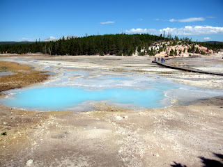
Last weekend we decided to explore the Midway Geyser Basin, about ten miles north of us, and hike to Fairy Falls. The Grand Prismatic Spring, a 250 by 350 foot hot spring, is the main attraction there. It is the largest hot spring in the park and the third largest in the world. When we walked up to it on the boardwalk it was so steamy that it was hard to see the beautiful colors. But when we began our hike to Fairy Falls there was a hillside that we climbed to get a picture from above. It was a pretty rugged to climb so we didn't go to the top. I remembered the saying "what goes up must come down." We had out walking sticks for balance but it was still hard to maneuver. This picture doesn't show the brilliant blue that we saw. Those little spots on the other side are people on the boardwalk.

The hike to Fairy Falls was about five miles round trip. It was mostly flat with shady areas of lodgepole pines contrasting with open areas with flowers that we had not seen before. Fairy Falls is a delicate, 197 foot waterfall named for its graceful beauty. We enjoyed a picnic lunch while watching and listening to it.


We walked past many other geysers, pools, and hot springs, and the Ranger told us about many of them and how they interact. The last stop was Morning Glory hot springs named from the morning glory flower. Back in the day (1800's) it was a beautiful blue color, but unfortunately it was vandalized in the 1950's when visitors took pieces of it for souvenirs and used it as a wishing well. Although it has been cleaned out it has not recovered its original beauty.

Last weekend we decided to explore the Midway Geyser Basin, about ten miles north of us, and hike to Fairy Falls. The Grand Prismatic Spring, a 250 by 350 foot hot spring, is the main attraction there. It is the largest hot spring in the park and the third largest in the world. When we walked up to it on the boardwalk it was so steamy that it was hard to see the beautiful colors. But when we began our hike to Fairy Falls there was a hillside that we climbed to get a picture from above. It was a pretty rugged to climb so we didn't go to the top. I remembered the saying "what goes up must come down." We had out walking sticks for balance but it was still hard to maneuver. This picture doesn't show the brilliant blue that we saw. Those little spots on the other side are people on the boardwalk.

The hike to Fairy Falls was about five miles round trip. It was mostly flat with shady areas of lodgepole pines contrasting with open areas with flowers that we had not seen before. Fairy Falls is a delicate, 197 foot waterfall named for its graceful beauty. We enjoyed a picnic lunch while watching and listening to it.

I was quite exhausted by the time we finished, but recovered after resting a bit. It was well worth the effort.
On another day off we decided to visit West Yellowstone, MT which is a small tourist town about 30 miles away with a population of around 1500 just west of the west gate into Yellowstone. We have been repeatedly reminded by Larry that it quite often is the coldest spot in the nation. Fortunately when we visited it the temperature was in the mid 70's and it was sunny. In addition to the visitor center, hotels, gift shops, and restaurants there are several interesting attractions. The ones we chose to see were the IMAX theater and Grizzly & Wolf Discovery Center. At the IMAX theater we viewed "Yellowstone" which was a movie depicting the many facets of the park including the history, geology, wildlife and plant life. It brought the park to life on the BIG screen.
We then proceeded to the Grizzly & Wolf Discovery Center. We arrived just in time to view the wolf feeding and hear an explanation of the four wolves that we were watching. This is McKinley who is the Alpha male of the pack.

And this is Leopold, McKinley's brother, who is the third ranking or Omega male on the pack.

They paced around and shortly after they were fed they curled up and relaxed in the grass. It was fascinating watching them. Since we haven't seen a wolf in the park we were happy to see some even though they were in captivity.
After walking through the naturalist cabin and eagle aviary we stopped at the bear habitat where two bears, Grant and Roosevelt, were tromping around and playing with each other. They were brought to the park last fall when their mother was euthanized out of concerns for public safety. They were born in 2011 and weigh about 250 pounds. There were ravens all around them, and at one point one of the bears took off after one of them. It was funny to watch their antics.

Before we left we watched a movie, "Living in Bear Country," which showed bears in the wilderness and the need to keep a safe distance away from them.
Since we still had time we decided to go back to the IMAX theater and see "Lewis and Clark" which was a story of their journey west and all the hardships that they encountered. It was amazing that only one person died on that trip. It makes me want to read and learn more about the Lewis and Clark trail. When we left the theater we noticed a snow coach beside the building. We had heard about tourists who come in winter when the roads are closed and are taken into the park on them. It looks like a fun way to travel in the snow but we won't be here to try it.

On our way back to Old Faithful we took a two mile road called Firehole Canyon Drive which is parallel to the main road but follows along the Firehole River. This is the area that is open to swimmers during August. The water is warm enough because the hot water from the springs and geysers flows into it. We saw swimmers enjoying it but didn't stop and go down to feel how warm it was. We did stop to see Firehole Falls, a 40 foot falls that was not spectacular but pretty in its own small way.

We worked four days this week, have three days off, work three days next week, and then we are finished for the season. We're beginning to get the RV ready for the trip and planning to visit a few places that we still want to see. Time has flown by so quickly, and we are somewhat sad that it is coming to an end.
Subscribe to:
Comments (Atom)